Saturday, 3 September 2016

A dynastic coin of Claudius

Claudius, Tetradrachm, c.45-6 AD, RPC I 5164

I recently acquired this “dynastic” coin, made in Alexandria, Egypt, of the emperor Claudius. His portrait is featured on the obverse of the coin. The reverse has a veiled female figure standing left. You would probably think of Demeter at first glance, however, the figure is named and that name is Messalina, Claudius’ third wife. In her hand, outstretched, there are two small children, Claudia Octavia and Britannicus.

Little is known about Messalina’s life prior to her marriage in 38 to Claudius, her first cousin once removed, who was then about 48 years old. Claudia Octavia was born in AD 39 or 40, a future empress, stepsister and first wife to the emperor Nero; and Britannicus in AD 41. When the Emperor Caligula was murdered in 41, the Praetorian Guard proclaimed Claudius the new emperor and Messalina became empress.

With her accession to power, Messalina enters history with a reputation as ruthless, predatory and sexually insatiable. Her husband is represented as easily led by her and unconscious of her many adulteries. In 48 AD, he went away on a trip and was informed when he returned that Messalina had gone so far as to marry her latest lover, the Senator Gaius Silius. While many would have ordered her death, the Emperor offered her another chance. Seeing this as weakness, one of his head officers went behind the Emperor's back and ordered Messalina's death. Upon hearing the news, the Emperor did not react and simply asked for another chalice of wine. The Roman Senate then ordered a damnatio memoriae so that Messalina's name would be removed from all public and private places and all statues of her would be taken down.

Sunday, 7 August 2016

Tarr Steps, Devon

The Tarr Steps, Devon, are a clapper bridge across the River Barle in the Exmoor National Park, Somerset, England. A typical clapper bridge construction, the bridge possibly dates to around 1000 BC.

The stone slabs weigh up to two tons each. According to local legend, they were placed by the devil to win a bet. Its age is unknown, as several theories claim that the steps date from the Bronze Age, c. 1000 BC, but others date them from around 1400 AD. It has been restored several times in recent years, following flood damage.

The steps have appeared on British stamps twice, in 1968 and 2015.

 1968 UK stamp

2015 UK stamp

Thursday, 14 July 2016

Iron Age or Roman beehive quern from the lower Wharfe valley


I have just been fortunate enough to acquire as a garden ornament an ancient beehive quern. Dating from the Iron Age or early/mid Roman times this quern was in a garden/architectural salvage dealers in an antiques warehouse in lower Wharfedale. Unpriced it appears the dealer was reluctant to sell as he had the idea of utilising the central grain funnel to make the piece into a water feature!

Beehive querns are a characteristic later pre-Roman Iron Age type, although their chronology has yet to be refined. They were the first characteristic quern shape to be introduced into Britain. The horizon of their introduction is likely to be late in the 4th century BC and they remained in use until replaced by Roman rotary querns, perhaps from late in the first century AD, a process which may have extended over at least a century, although, again, the chronology has yet to be clarified.


In West Yorkshire querns are important as an indicator of the general distribution of later pre-Roman Iron Age settlement, subject to the usual caveats regarding the presence or absence of fieldworkers and museums, and other variables affecting their discovery and reporting.

Querns are particularly prevalent in the valleys of the rivers Wharfe and Aire, the distribution thinning out on the Pennine uplands and in the lower parts of the Vale of York. This pattern presumably reflects limited populations, but the thinning of the distribution in South Yorkshire may be a function of observation and recording. Within the general distribution pattern it is of particular interest to note the iffering distribution of ‘tall’ querns with sides of greater than 70 degrees to base and 'hemispherical' querns with sides of less than 60 degrees to base. While hemispherical querns are particularly found in North Yorkshire and the Tees valley, ‘tall’ querns are a feature of West Yorkshire, suggesting a cultural distinction which may also be reflected in the ritual and burial traditions noted above.

How long it took flat rotary querns to supplant beehive querns remains unclear, but it is likely that the use of beehive querns did not extend into the 3rd century AD.

Sunday, 10 July 2016

Joseph Palmer and Edward Palmer

Seeing the posts on the internet about the Somme has prompted me to post about my two great uncles who died in the Great War and are named on the Thorner (near Leeds, West Yorkshire) war memorial, even though they were later casualties.
Private Joseph Richardson Palmer
It took me a while to identify which picture belonged to which person as neither is named but, from examination of cap badges and tunic buttons, I think I’ve got the correct attribution.
 Death notice Private Joseph Palmer
 The first, Private Joseph Richardson Palmer, was in the Leicestershire Regiment. He died of wounds in the 1st Australian Hospital in Rouen on 4th June 1918, aged 23, purportedly from an air raid on the hospital where he was being treated. He is buried in St. Sever cemetery extension, Rouen.

Private Edward Goodwill Palmer

The second, Private Edward Goodwill Palmer, aged 19, in the Essex Regiment was killed on September 21st 1918 aged 19. He is buried in Unicorn cemetery, Vendhuile.


Thorner parish magazine cover, November 1918
His death was reported in the November parish magazine, obviously published just before the declaration of the armistice. Two other village war deaths are recorded in the magazine, Private Percy Yates, died of wounds on 6th October, and Private Herbert Mitchell MM, October 17th and who is buried in Thorner churchyard.
Thorner parish magazine text, November 1918

Sunday, 19 June 2016

Three ancient Greek fractional coins

This isn’t an oversized pound coin, it is a normal 22.5mm diameter piece, yet it comfortably displays three ancient Greek fractional silver coins.

1.
Kolophon in Ionia
AR hemiobol
c.5th cent BC
O - Head of Apollo right
R - Pebbled quadripartite incuse square with pellet in centre
Klein 401v

2.
Kolophon in Ionia
AR hemiobol
6th cent BC
O - Archaic female head left
R - Quadripartite incuse square
SNG Kayham 342, SNG von Aulock 1808

Kolophon  was an ancient city in Ionia. Founded around the turn of the first millennium BC, it was likely one of the oldest of the twelve cities of the Ionian League. In ancient times it was located between Lebedos (120 stadia to the west) and Ephesus (70 stadia to its south). Today the ruins of the city can be found south of the town DeÄŸirmendere Fev in the Menderes district of Izmir Province, Turkey.

The city's name comes from the word κολοφών, "summit", which is also the origin of the bibliographic term "colophon", in the metaphorical sense of a 'crowning touch', as it was sited along a ridgeline. The term colophony for rosin comes from the term colophonia resina, that is, resin from the pine trees of Kolophon, which was highly valued for the strings of musical instruments.

3.
Kyzikos in Mysia
AR hemiobol
480-450 BC
O - Forepart of boar left, tunny fish behind
R - Head of lion left, cross above
SNG Cop 49

Kyzikos was an ancient town of Mysia in Anatolia in the current Balıkesir Province of Turkey. It was located on the shoreward side of the present Kapıdağ Peninsula (the classical Arctonnesus), a tombolo which is said to have originally been an island in the Sea of Marmara only to be connected to the mainland in historic times either by artificial means or an earthquake.

Today the site of Kyzikos, located on the Erdek and Bandırma roads, is protected by Turkey's Ministry of Culture. Historically the monuments of Kyzikos were used by the Byzantine emperor Justinian as a quarry for the building of his Saint Sophia cathedral, and were still exploited by the Ottomans.

Sunday, 17 April 2016

Knaresborough Priory and St Robert's cave

I took a walk along the course of the River Nidd in Knaresborough today and happened upon Abbey Road. Along this road the long destroyed Knaresborough Priory was located.


The Trinitarian Priory of the Holy Trinity and St Robert, was founded pre-1252. It was destroyed by the Scots in 1318, and suffered at the Black Death. It was dissolved in 1538. Excavations in 1862 and 1949 have recovered the plan of the North transept of the church with towers or turrets at the angles, a South-East buttress, and stone coffins. This was North-West of the later building called `The Priory'. A possible malthouse was exposed South-East of `The Priory'. To the South of this, a possible dovecote was found by remote survey in 1971.


Part of the South precinct wall survives in the garden of Abbey House, and the `Priory' stands on earlier, possible monastic foundations. Parts of the priory buildings are also preserved in the wall and buildings of “The Priory” on Abbey Road.


Further along the road is the cave of “Saint” Robert of Knaresborough, a hermit who lived in a cave by the River Nidd. His feast day is 24th September. Although never officially canonised Robert is considered as one of the outstanding saints of the early thirteenth century.

St Robert lived in various places in the vicinity of Knaresborough before taking up residence in a cave by the river Nidd (then known as St. Giles' Priory). It is said that King John visited him and Trinitarian friars also venerated him. Towards the end of his life, pilgrims flocked to see Robert to seek spiritual guidance and to be healed of physical ailments. His brother Walter, then Mayor of York, came and paid for some new buildings, including a chapel dedicated to the Holy Cross.

Monday, 28 March 2016

The German victories of Gallienus

Gallienus
Antoninianus
Reverse: GERMANICVS MAX V
Two captives seated back-to-back flanking the foot of a trophy of captured equipment, their arms tied behind their backs

In the late 250s the emperor Gallienus was based in Cologne orchestrating the campaign against the barbarians that were crossing from the free lands on the western Rhine and then eastern Rhine.

A major invasion by the Alemanni and other Germanic tribes occurred between 258 and 260 (it is hard to fix the precise date of these events), probably due to the vacuum left by the withdrawal of troops supporting Gallienus in the campaign against the rebel Ingenuus. Franks broke through the lower Rhine, invading Gaul, some reaching as far as southern Spain, sacking Tarraco (modern Tarragona). The Alamanni invaded, probably through Agri Decumates (an area between the upper Rhine and the upper Danube), likely followed by the Juthungi. After devastating Germania Superior and Raetia (parts of southern France and Switzerland), they entered Italy, the first invasion of the Italian peninsula, aside from its most remote northern regions, since Hannibal 500 years before.

When invaders reached the outskirts of Rome, they were repelled by an improvised army assembled by the Senate, consisting of local troops (probably praetorian guards) and the strongest of the civilian population. On their retreat through northern Italy, they were intercepted and defeated in the battle of Mediolanum (near present-day Milan) by Gallienus' army, which had advanced from Gaul, or from the Balkans after dealing with the Franks. The battle of Mediolanum was decisive, and the Alamanni didn't bother the empire for the next ten years. The Juthungi managed to cross the Alps with their valuables and captives from Italy. An historian in the 19th century suggested that the initiative of the Senate gave rise to jealousy and suspicion by Gallienus, thus contributing to his exclusion of senators from military commands


The coin here features, on one side, Gallienus in the spiky, radiate crown, wearing a cloak over his military armour. The other side proclaims a victory against the Germanic tribes and shows two barbarian captives below a trophy of arms.

It is available for purchase from the Mauseus Vcoins inventory, HERE, £35.

Monday, 21 March 2016

Bainbridge Roman fort


I found myself in the Yorkshire Dales on Sunday and decided to head on up to Bainbridge to see the Roman fort.

The very well-defined almost square-shaped earthworks of Bainbridge Roman fort, lie just a little to the east of the village on the opposite side of the river Bain (England’s shortest river) at a place called Brough. The Romans called this fort Virosidvm – ‘the settlement of true men’. Thought to have been built in the Late Flavian period and abandoned by the late 4th century, it has a single ditch surrounding the north, east and south sides.

Three Latin inscribed building and military-type stones found here record that rebuilding took place after it was burnt to the ground in the early 3rd century AD – the rebuilding being carried out by the VI cohort of Nervi or Cohors Sextae Nerviorum. An earlier 2nd century timber fort was replaced by one made of stone, something that happened at many Roman forts in Brittannia. As well as the three stones with Latin inscriptions a further stone bearing a crudely carved mermaid was discovered and also substantial amounts of metalworking material and ingot moulds. It is believed there are Roman stones built into a number of cottages and farm buildings in and around Bainbridge.

The photograph of the fort was taken from the road leading up to Semerwater. Semerwater is the largest of only three natural water bodies in Yorkshire. It is a glacial lake which was formed at the end of the last Ice Age when huge amounts of glacial till blocked the outflow from Raydale.

Tuesday, 15 March 2016

A medallion of Marcus Aurelius

I have just acquired an extremely rare medallion of Marcus Aurelius.


Marcus Aurelius
AE medallion
Rome mint
Obv: M AVREL ANTONINVS AVG GERM SARM TRP XXXII
Laureate, draped bust right
Rev: IMP VIIII COS III PP
Emperor standing right, turning left and crowning a trophy of arm with two captives below
Gnecchi II, pl 59, 6 (obv), Gnecchi II, pl 60, 9 (rev)

Medallions were produced during the Roman empire predominantly as new year gifts. The dating on this medallion, using the TRP, IMP and COS titles, show this medallion was struck for the year December 177 to December 178 AD for the 1st of January 178 AD.

Gnecchi II, pl 60, 9


The dating of the medallion, with the reverse type that clearly shows a scene of victory with the trophy of arms with the captives seated below, must be a celebration of the outcome of the first Marcomannic war (162 through to 176). On December 23rd Marcus Aurelius, together with his son Commodus, celebrated a joint triumph for his German victories ("de Germanis" and "de Sarmatis" that appear in the obverse titles of this medallion). I suspect the victory celebration occurred too late for the medallions for January 1st 177, given the iconography of the reverses of the other medallions dated to TRP XXXII (December 177-178).


Gnecchi II, pl 59

In commemoration of this victory the Aurelian Column was erected, in imitation of Trajan's Column.

The Aurelian column

Sunday, 7 February 2016

Burgh Castle and Caistor, Norfolk


In 2015 I had a summer break in Norfolk. It is such a historic county and I had the opportunity to visit a few Roman site whilst there. Included in that is what must be my second favourite Roman site of Burgh Castle.

Burgh Castle

Gariannonum, or Gariannum, was a Saxon Shore fort in Norfolk, England. The Notitia Dignitatum, a Roman Army “order of battle” from about AD 400, lists nine forts of the Saxon Shore in south and east England, among which one was called Gariannonor. It has been much discussed over the years in terms of spelling (Gariannonum, Garianonum, Gariannum), purpose (whether it really was intended for defence against Saxon raids), and location (whether Burgh Castle or the Caister-on-Sea site).

 Caistor Roman fort

Gariannonum has usually been identified with Burgh Castle. However, modern reassessment of the Roman settlement 9 kilometres (5.6 mi) away at Caister-on-Sea has shown that it too had a military function. In Roman times, both sites lay on opposite sides of a large estuary (the remnant of which is Breydon Water). The identification of Burgh Castle as Gariannonum is uncertain, and the name could apply to Caister-on-Sea.

Burgh Castle

The name Gariannonum has been thought to derive from a Celtic root meaning "babbling river," which may refer to the River Yare at Burgh Castle, although the derivation is uncertain. The military function of Caister-on-Sea is also open to doubt. Both sites probably operated together and one, or possibly even both, were known by the Romans as Gariannonum.

The fort is roughly rectangular measuring (internally) approximately 205 m (673 ft) by 100 m (330 ft). The walls on the north, east, and much of the south side are largely intact, standing at a height of approximately 4.6 m (15 ft) and measuring up to 3 m (9.8 ft) thick at the base. They have a core of mortared flint rubble and an external and internal facing of prepared flint and red tile or brick in alternating bands. Against the outer face of the walls there are six solid bastions of pear-shaped plan spaced symmetrically, two on the south wall, one each at the north east and south east angles, one slipped from position on the north wall, and one below the south wall where it has fallen. The west wall has at some time in the distant past collapsed down the underlying hillside and into what was once an estuary but is now a marsh, and nothing of it is now visible. Breydon Water is all that is left of the estuary this fort once overlooked.

Burgh Castle

Coin and pottery evidence on the site indicates that the occupation of the fort dates from the mid-3rd century AD, with Roman occupation continuing up to the early 5th century AD when the integration of Roman and Saxon traditions appear.

Saturday, 23 January 2016

The Mithreum at Carrawburgh


I had the opportunity this weekend to visit the temple dedicated to Mithras on Hadrian’s Wall behind the auxiliary fort of Brocolita at Carrawburgh, Northumberland.

The remains of an early 3rd century mithraeum was discovered in 1949 and excavated by Ian Richmond and J.P. Gillam in 1950, and is the second-most northernly mithraeum discovered so far. The Brocolitia mithraeum is also the only sanctuary outside the Rhine provinces from which a monument of the goddess Vagdavercustis has been recovered. Like most other mithraea, the Brocolitia temple was built to resemble a cave, and also had the usual anteroom, and a nave with raised benches (podia) along the sides. At Brocolitia, the anteroom and nave were separated by a wattle-work screen, the base of which was found exceptionally well preserved.


The three altars found there were all dedicated by commanding officers of the unit stationed here, the First Cohort of Batavians, a Germanic people from the Rhineland. From left to right in the picture the named commanders are Marcus Simplicius Simplex (RIB 1546), Lucius Antonius Proculus (RIB 1544) and Aulus Cluentius Habitius (RIB 1545).

Mithraism is a Persian religion, with many aspects similar to another minor eastern Roman religion, Christianity, where the proponents are given the hope of a better afterlife rather than improving the current life and through this became a favourite of the Roman army.

Monday, 18 January 2016

The Roman mosaic from Well


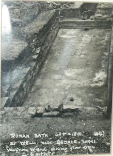
On my recent visit to Masham I had the opportunity to photograph a Roman mosaic that I had wanted to see for a long time, but for one reason or another never had. The pavement fragment from a villa and bath house complex is located in the church in the nearby village of Well.
 
The corner fragment of mosaic that is preserved features various classic designs of both guilloche and latchkey for the border and a central geometric design that imitates cubes in 3d. It dates presumably from the third or perhaps fourth century AD.

Sunday, 10 January 2016

The Temple of Aphrodite, Paphos, Cyprus


AE19mm, Augustus, Paphos, RPC I 3906
It’s been a long time since I visited the temple of Aphrodite at Palaeo Paphos, also known as Kouklia, on the island Cyprus, so much so that I can’t find the photographs that I took (back in October 2000). However a recent coin acquisition has taken me back there.


The coin, of the emperor Augustus from the island of Cyprus, features the temple as its reverse design with, at its centre, the conical meteoric stone that was the main feature of devotion at the temple site.


The Histories of Tacitus record a visit by the emperor Titus to the site in the first century AD:

“While he was in Cyprus, he (Titus) was overtaken by a desire to visit and examine the temple of Paphian Venus, which was famous both among natives and strangers. It may not prove a wearisome digression to discuss briefly the origin of this cult, the temple ritual, and the form under which the goddess is worshipped, for she is not so represented elsewhere.

The founder of the temple, according to ancient tradition, was King Aerias. Some, however, say that this was the name of the goddess herself. A more recent tradition reports that the temple was consecrated by Cinyras, and that the goddess herself after she sprang from the sea, was wafted hither; but that the science and method of divination were imported from abroad by the Cilician Tamiras, and so it was agreed that the descendants of both Tamiras and Cinyras should preside over the sacred rites. It is also said that in a later time the foreigners gave up the craft that they had introduced, that the royal family might have some prerogative over foreign stock. Only a descendant of Cinyras is now consulted as priest. Such victims are accepted as the individual vows, but male ones are preferred. The greatest confidence is put in the entrails of kids. Blood may not be shed upon the altar, but offering is made only with prayers and pure fire. The altar is never wet by any rain, although it is in the open air. The representation of the goddess is not in human form, but it is a circular mass that is broader at the base and rises like a turning-post to a small circumference at the top”

Another interesting feature of the coin is that the reverse bears the name A Plautius, Proconsul. Michael Grant, in his book ‘From Imperium to Auctoritas’, suggests that this may be the father of Aulus Plautius, the conqueror of Britain and first governor of the province in 43 AD, leading his invasion in support of Verica, king of the Atrebates and an ally of Rome, who had been deposed by his eastern neighbours the Catuvellauni.

Saturday, 2 January 2016

A Vampire near Masham


Driving up a small valley outside of Masham in North Yorkshire the other day I came across a pair of severed wings with RAF roundels painted on them. I was curious as to the aeroplane type that had originally had  them fitted so I grabbed a quick photograph.

I initially thought of a Canberra or perhaps a Meteor, however the curved fairing under the wing was wrong, plus the wheels on both of those aircraft point towards the fuselage whereas on these wings they point away. Then it came to me, the de Havilland Vampire. Sure enough the wheel alignment was correct and the visible fairing on the wing is from the tail boom.